
Lot n° 253 | Auction 625
Estimate € 300 - 500
Sold € 950
Auction: 19 September 2023 at 15:00
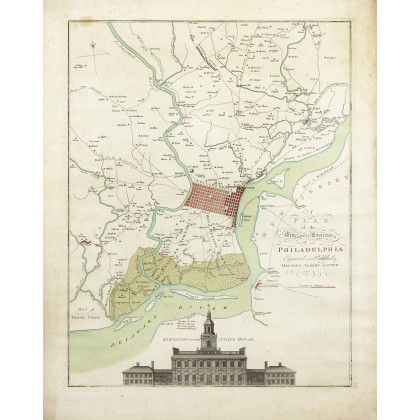
[AMERICA - RIVOLUZIONE - MAPPA] - LOTTER, Matthias Albrecht (1741-1810) - Nicholas SCULL (1687-1762) - George HEAP (attivo 1715-1760) - Plan of the City and Environs of Philadelphia. S.L: Matthew Albert Lotter, 1777 data di stampa riportata sulla mappa - su carta vergata, ma senza filigrana. A fine copy of the renown map of Philadelphia made during the years of the American Revolution and hand coloured at the time. At the bottom edge a detailed prospectus of the "State House", now known as "Independence Hall", the place of the signing of the Declaration of Independence and the center for the debate and adoption of the American Constitution. When first issued in 1752, the famous Scull and Heap plan was intended to promote William Penn's new city on the Delaware. When the events of the American Revolution began to heat up, illustrations of the center of the revolt at Philadelphia began to be in great demand in Europe. This demand was soon met by publishers in England, Germany and France with the reissue of the Scull and Heap map, then still considered the most up-to-date cartographic treatment of Philadelphia then available. Holmes' grid Plan for the City is shown situated between the rivers, and numerous outlying 'country seats' are placed and named, with the primitive road system also indicated. Lotter updated it from the first edition to take into account the changes in the place names and environs of the city since the middle of the century, and Heap's elevation of the statehouse was moved from the top to the bottom center of the plate. (710 x 573mm). Engraved map with contemporary handcolouring using the typical colours also used in other copies, within an elegant frame decorated in green and gold (frame measurements 745 x 608mm). (Some wear to edges including small tears and browning). Printed on laid paper, but without watermark.
Estimate € 300 - 500